Continuamos corrigindo bugs e adicionando pequenas melhorias para melhorar sua experiência.
Foi adicionado o suporte para o FlyBeeper Bluetooth vario e para o rastreamento ao vivo FFVL.
Os pop-ups de espaços aéreos agora mostram os nomes dos espaços aéreos.
Continuamos corrigindo bugs e adicionando pequenas melhorias para melhorar sua experiência.
Uma solução alternativa para uma falha no iOS 17.4 que impedia o acesso aos dados de pressão do ar.
Continuamos corrigindo bugs e adicionando pequenas melhorias para melhorar sua experiência.
Continuamos corrigindo bugs e adicionando pequenas melhorias para melhorar sua experiência.
Alguns bugs que poderiam causar um travamento foram corrigidos.
Pequenas melhorias e correções de bugs.
A nova extensão "Social" permite o uso total dos recursos de rastreamento ao vivo. Isso torna o voo em conjunto muito mais agradável e fácil. Também lhe dá a vantagem de saber o que os outros estão fazendo, onde estão ganhando ou perdendo, por exemplo.
A extensão permite o uso dos servidores de rastreamento XContest Live e SportsTrackLive.
A localização de outros pilotos no mapa é mostrada com sua direção de voo, tipo de aeronave, altitude e elevação, se desejado. Antes daquele longo voo, compartilhe facilmente as configurações de rastreamento com seus amigos, para que possam acompanhar uns aos outros durante o voo.
Correzione di bug che si spera risolva i problemi di avvio con cui alcuni di voi stanno lottando.
Alguns relataram problemas de inicialização com a versão anterior. Estes são, esperamos, resolvidos agora.
Um instrumento "Altitude GPS" agora está disponível como parte da extensão XC.
E continuamos fazendo pequenas melhorias no aplicativo.
Flyskyhy agora está disponível em espanhol e português, muito obrigado a Marco Campazas e Rafael Damiati Ferreira pelas traduções.
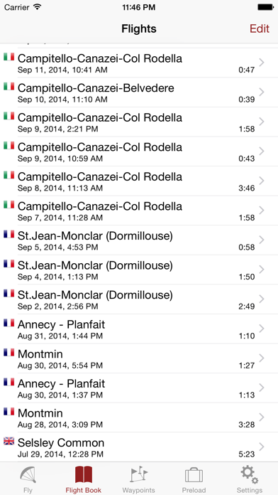
Agora você pode organizar seus registros de voos. Eles estão agrupados automaticamente por ano, mas você pode escolher qualquer critério adicional que desejar. Faça um grupo para todos os seus voos longos, organize-os pelo equipamento que você voou e/ou mantenha suas decolagens tradicionais separadas das rebocadas. Para cada grupo, o aplicativo irá calcular automaticamente o tempo e a distância total de voo.
Você também pode exportar os dados dos grupos de voos como uma planilha. Isso permite que você mesmo manipule os dados com ferramentas de planilhas comuns.
Flyskyhy now comes with Italian texts, many thanks to Iacopo Boccalari for the translations!
We continue to enhance the app with improvements and bug fixes. The CPU usage has been reduced, and excessive usage of the CPU in the background has been tackled. Various other small issues are solved.
- Digifly Air is now supported as Bluetooth vario for lift, altitude, and GPS data.
- The wind indicator is improved further. It works better for cliff soaring, adapts faster to changing winds, and in general indicates a slightly stronger wind than before.
- The glide ratio indicator will respond faster to variations in your glide ratio.
- Generic support has been added for other Bluetooth LE varios
Bug fixes:
- Icons on the status bar in portrait mode will be visible again on all iPhone models with a screen notch.
- Digifly Air is now supported as Bluetooth vario for lift, altitude, and GPS data.
- The wind indicator is improved further. It works better for cliff soaring, adapts faster to changing winds, and in general indicates a slightly stronger wind than before.
- The glide ratio indicator will respond faster to variations in your glide ratio.
- Generic support has been added for other Bluetooth LE varios
Map:
The map for planning purposes is now available for everybody, not just those who have purchased the Waypoints extension. The preload tab has been removed, and is replaced by the waypoints list functionality.
Preload:
Unfortunately, Google charges money for downloading maps. Until now, I have paid for your downloads myself, but that is no longer sustainable. Therefore, from now on, you will need a subscription for preloading maps in Flyskyhy. Purchase the subscription in the Settings, like the other extensions.
Preloading a certain area has been made a lot easier, simply tap on the download symbol on the Map screen.
Improvements:
Two bugs have been fixed that could possibly lead to a crash of the app.
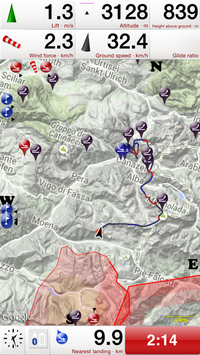
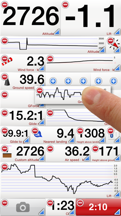
You can now configure the Lift instrument to show a running average over a longer period. You can set a different averaging period for each Lift instrument, such that you can have both the direct Lift and the average Lift side by side on your dashboard.
A number of small bugs have been fixed as well, among others:
• Https is now the default for uploads to Leonardo servers, with automatic switch to http if https fails.
• Fixed connection problems with FlyTec SensBox
In this version a work-around for the iOS 13 “open in” bug is added. If Flyskyhy does not appear in the iPhone “Open in” dialogue when opening a waypoints, airspaces extension, or external igc file, you can use this work-around. In that case choose “Save to Files” instead. Then select “On My iPhone” and “Flyskyhy”, and tap “Save” in the top-right corner. Now open Flyskyhy, and a popup should come up asking whether to import the new airspaces or waypoints. New IGC files wil simply appear in the flights list.
This version also has a work-around for the iOS “90 degrees” bug. For some people, the compass heading differed 90 degrees from the real heading due to incorrect compass data in iOS 13 and possibly iOS 12.4. This had also consequences for the indicated direction of the ground speed, wind calculations, and various other issues. To solve the bug, other data in the iPhone is now used, and more rigorously filtering for incorrect data is applied.
During a flight, all sensor data is now logged in a special debug log. The sensor data is kept for the last flight, and can be sent to me through a button at the bottom of the flight details view. Hopefully this will help with future improvement of the sensor data algorithms.
Various other small bugs are fixed as well.
This version adds the following new functionality:
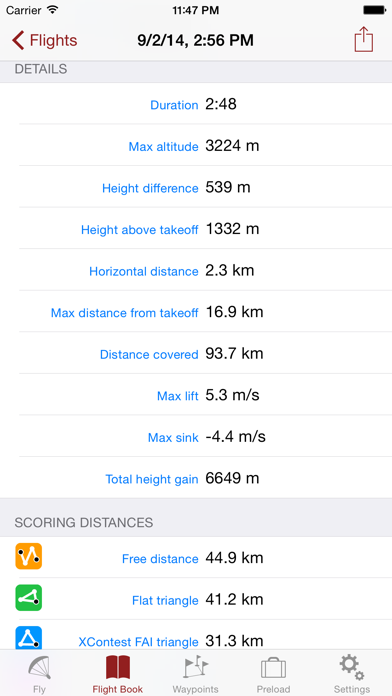
• Support for the new XContest 5% rule for FAI triangles
• More responsive automatic switching back and forth to the thermal centring instrument
• Max ground speed is now shown in flight details
• Wind calculation is less nervous
A number of smaller bugs are also fixed, with some general improvements
New in this version:
• It is now possible to see the Flyskyhy flight logs from web page upload menus. This enables direct flight upload to web-sites, without having to store the flight log in an intermediate app first.
• Support for XCTracer FLARM device: the reported aircraft will be shown on the map
• Added support for reading .xctsk files generated by xcplanner
• Added instrument that shows expected arrival height above next waypoint
• Added instrument for expected arrival height above the goal waypoint
• Improved wind calculation
Bugfixes:
• Fix upload to DHV / Leonardo for Tandem flights
• Adapted to ignore accessibility font size settings.
• Fixed bug with airspaces files that are not UTF-8 encoded
• .xctsk files can now have description fields
• Adapted to use specific "Airborne" GPS type introduced by Apple in iOS-12
On popular demand, the main addition in this version are obstacles such as power lines and lift cables added to the airspaces data. Currently only obstacles for Switzerland are available, but the planning is to gradually add obstacles for other countries as well. To cater for that, it is now also possible to set different warning preferences for different airspace classes. There is some more choice in colours for airspaces/obstacles as well.
This version also makes it possible to add your own airspaces file. To do that, open the OpenAir file with .txt extension, and the iPhone will ask to import it in Flyskyhy.
Various other additions / fixes:
• Adapted for iOS 12 and the new iPhone models
• Support for XCTrack task file format
• Support for XCTrack QR codes
• Support for reading of GPX routes
• More robust handling of faulty data sent by Bluetooth devices
• Prevent accidental screen editing while in a flight
• Prevent airspaces and take-off / landing sites from disappearing in low memory situations
• Fixed various small bugs
••••••••• IMPORTANT •••••••••
Google has changed their contracts for using Google Maps. As a result, Flyskyhy had to be changed. You MUST install this upgrade, otherwise you will no longer be able to see maps in the app after June 11th.
In conjunction with that, the highest resolutions maps will no longer be pre-loaded, in order to limit the potential costs for map loading.
This version introduces Skylines.aero as live tracking site, in addition to LiveTrack24 and Loctome.
The app will now calculate the Open Distance (2-point distance) for your flights.
Bugfixes:
• Taking a picture with the iPhone in landscape orientation, will no longer rotate the screen 180 degrees
• You will now get an alert when Bluetooth is switched off
• When editing the screens, releasing a dragged instrument during a page switch will no longer lead to a crash
• The indicated course is now also correct when replaying non-Flyskyhy logs
• The current triangle sector now updates more frequently when replaying a flight
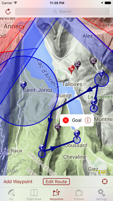
On popular demand, a number of improvements to the Waypoints Extension have been added, which makes it even more suited for competitions. Waypoints can now also represent finish lines. And you can earmark a waypoint as End of Speed Section (ESS), which directs the optimised route along the shortest path straight to the waypoint, without considering subsequent waypoints. The original optimised route is kept on the map as a dashed line.
It is now no longer required to restart the app when selecting a new Bluetooth vario. Accidentally selecting a Bluetooth vario as FLARM device will no longer lead to a crash. A number of smaller bugs have been fixed as well.
The GPS version of BlueFlyVario is now supported.
A number of bugs have been fixed as well. Paramotor uploads to XContest are now handled correctly. A number of small bugs when editing screens have now been fixed. And it is no longer required to restart the app for any Settings changes. Some rare crashes will be prevented as well.